Antarctica
From Wikipedia, the free encyclopedia
Antarctica
(Antarctic
Treaty Secretariat emblem)

Area
14,000,000 km²
(5,405,430 mi²) (280,000 km² (108,108 mi²) ice-free,
13,720,000 km² (5,297,321 mi²) ice-covered)
Population
~1000
(none permanent)
Government
– Executive Secretary
governed by the Antarctic
Treaty Secretariat
Johannes Huber
Partial Territorial claims (subject to the Antarctic
Treaty System)
 Argentina
 Australia
 Chile
Chile
 France
 New Zealand
 Norway
 United
Kingdom
United
Kingdom
Reserved the right to make
claims
 Russia
 United
States
United
States
Internet TLD
.aq
Calling Code
+672
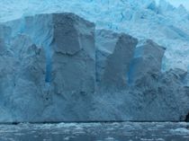
Antarctic
Peninsula glacier.
Antarctica is Earth's southernmost continent
and includes the South Pole. Geographic sources disagree as to whether it is
surrounded by the Southern Ocean or the South Pacific Ocean, South Atlantic
Ocean, and Indian Ocean. It is divided by the Transantarctic Mountains. On
average, it is the coldest, driest, and windiest continent, and has the highest
average elevation of all the continents.[1] At 14.425
million km², Antarctica is the third-smallest continent before Europe and Australia;
98% of it is covered in ice. Because there is little precipitation, except at
the coasts, the interior of the continent is technically the largest desert in
the world. There are no permanent human residents and Antarctica has never had
an indigenous population. Only cold-adapted plants and animals survive there,
including penguins, fur seals, mosses, lichens, and many types of algae. The
name "Antarctica" comes from the Greek ανταρκτικός (antarktikos), meaning
"opposite to the Arctic."[2]
Although myths and
speculation about a Terra Australis ("Southern Land") date
back to antiquity, the first confirmed sighting of the continent is commonly
accepted to have occurred in 1820 by the Russian expedition of Mikhail Lazarev
and Fabian Gottlieb von Bellingshausen. However, the continent remained largely
neglected for the rest of the 19th century because of its hostile environment,
lack of resources, and isolated location.
The Antarctic Treaty was
signed in 1959 by 12 countries. The treaty prohibits military activities and
mineral mining, supports scientific research, and protects the continent's ecozone.
Ongoing experiments are conducted by more than 4,000 scientists of many
nationalities and with different research interests.[3]
History
Belief in the existence of
a Terra Australis — a vast continent located in the far south of the
globe to "balance" the northern lands of Europe, Asia and north
Africa — had existed since Ptolemy, who suggested the idea in order to preserve
symmetry of landmass in the world. Depictions of a large southern landmass were
common in maps such as the early 16th century Turkish Piri Reis map. Even in
the late 17th century, after explorers had found that South America and Australia
were not part of "Antarctica," geographers believed that the
continent was much larger than its actual size.

Mount
Herschel, Antarctica
European maps continued to
show this land until Captain James Cook's ships, HMS Resolution and Adventure,
crossed the Antarctic Circle on January 17, 1773 and again in 1774.[4] The first confirmed sighting of Antarctica can be
narrowed down to the crews of ships captained by three individuals. According
to various organizations (the National Science Foundation,[5]
NASA,[6] the University of California, San Diego,[7] and other sources[8][9]), ships
captained by three men sighted Antarctica in 1820: Fabian von Bellingshausen (a
captain in the Russian Imperial Navy), Edward Bransfield (a captain in the
British Navy), and Nathaniel Palmer (an American sealer out of Stonington,
Connecticut). Von Bellingshausen supposedly saw Antarctica on January 27, 1820,
three days before Bransfield sighted land, and ten months before Palmer did so
in November 1820. On that day the two ship expedition led by Von Bellingshausen
and Mikhail Petrovich Lazarev reached a point within 32 km (20 miles)
of the Antarctic mainland and saw ice fields there.
In 1841, explorer James
Clark Ross passed through what is now known as the Ross Sea and discovered Ross
Island. He sailed along a huge wall of ice that was later named the Ross Ice
Shelf. Mount Erebus and Mount Terror are named after two ships from his
expedition: HMS Erebus and Terror.[10] The
first documented landing on mainland Antarctica was by the American sealers John
Davis in Western Antarctica on February 7, 1821, and Mercator Cooper in Eastern
Antarctica on January 26, 1853.[11]

The
Endurance at night
during Ernest Shackleton's Imperial Trans-Antarctic Expedition in 1914.
During an expedition led by
Ernest Shackleton in 1907, parties led by T. W. Edgeworth David became the
first to climb Mount Erebus and to reach the South Magnetic Pole.[12] In addition, Shackleton himself and three other members
of his expedition made several firsts in December 1908 - February 1909: first
humans to traverse the Ross Ice Shelf, the first humans to traverse the
Transantarctic Mountain Range (via the Beardmore Glacier), and the first humans
to set foot on the South Polar Plateau. On December 14, 1911, a party led by
Norwegian polar explorer Roald Amundsen from the ship Fram became the
first to reach the geographic South Pole, using a route from the Bay of Whales
and up the Axel Heiberg Glacier.[13]
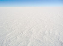
Ice cap.
Although other pictures in this article show interesting features, this
represents a "typical" picture of Antarctica, nothing but a flat
white snowfield. (Photo is from Dome C, but it would look the same from South
Pole, Vostok, etc.)
Richard Evelyn Byrd led
several voyages to the Antarctic by plane in the 1930s and 1940s. He is
credited with implementing mechanized land transport and conducting extensive
geological and biological research.[14] However, it was
not until October 31, 1956 that anyone set foot on the South Pole again; on
that day a U.S. Navy group led by Rear Admiral George Dufek successfully landed
an aircraft there.[15]
|
Antarctica |
|
|
(Antarctic
Treaty Secretariat emblem)
|
|
|
Area |
14,000,000 km²
(5,405,430 mi²) (280,000 km² (108,108 mi²) ice-free,
13,720,000 km² (5,297,321 mi²) ice-covered) |
|
Population |
~1000
(none permanent) |
|
Government |
governed by the Antarctic
Treaty Secretariat |
|
Partial Territorial claims (subject to the Antarctic
Treaty System) |
|
|
Reserved the right to make
claims |
|
|
Internet TLD |
.aq |
|
Calling Code |
+672 |
Antarctic
Peninsula glacier.
Antarctica is Earth's southernmost continent
and includes the South Pole. Geographic sources disagree as to whether it is
surrounded by the Southern Ocean or the South Pacific Ocean, South Atlantic
Ocean, and Indian Ocean. It is divided by the Transantarctic Mountains. On
average, it is the coldest, driest, and windiest continent, and has the highest
average elevation of all the continents.[1] At 14.425
million km², Antarctica is the third-smallest continent before Europe and Australia;
98% of it is covered in ice. Because there is little precipitation, except at
the coasts, the interior of the continent is technically the largest desert in
the world. There are no permanent human residents and Antarctica has never had
an indigenous population. Only cold-adapted plants and animals survive there,
including penguins, fur seals, mosses, lichens, and many types of algae. The
name "Antarctica" comes from the Greek ανταρκτικός (antarktikos), meaning
"opposite to the Arctic."[2]
Although myths and
speculation about a Terra Australis ("Southern Land") date
back to antiquity, the first confirmed sighting of the continent is commonly
accepted to have occurred in 1820 by the Russian expedition of Mikhail Lazarev
and Fabian Gottlieb von Bellingshausen. However, the continent remained largely
neglected for the rest of the 19th century because of its hostile environment,
lack of resources, and isolated location.
The Antarctic Treaty was
signed in 1959 by 12 countries. The treaty prohibits military activities and
mineral mining, supports scientific research, and protects the continent's ecozone.
Ongoing experiments are conducted by more than 4,000 scientists of many
nationalities and with different research interests.[3]
History
Belief in the existence of
a Terra Australis — a vast continent located in the far south of the
globe to "balance" the northern lands of Europe, Asia and north
Africa — had existed since Ptolemy, who suggested the idea in order to preserve
symmetry of landmass in the world. Depictions of a large southern landmass were
common in maps such as the early 16th century Turkish Piri Reis map. Even in
the late 17th century, after explorers had found that South America and Australia
were not part of "Antarctica," geographers believed that the
continent was much larger than its actual size.
Mount
Herschel, Antarctica
European maps continued to
show this land until Captain James Cook's ships, HMS Resolution and Adventure,
crossed the Antarctic Circle on January 17, 1773 and again in 1774.[4] The first confirmed sighting of Antarctica can be
narrowed down to the crews of ships captained by three individuals. According
to various organizations (the National Science Foundation,[5]
NASA,[6] the University of California, San Diego,[7] and other sources[8][9]), ships
captained by three men sighted Antarctica in 1820: Fabian von Bellingshausen (a
captain in the Russian Imperial Navy), Edward Bransfield (a captain in the
British Navy), and Nathaniel Palmer (an American sealer out of Stonington,
Connecticut). Von Bellingshausen supposedly saw Antarctica on January 27, 1820,
three days before Bransfield sighted land, and ten months before Palmer did so
in November 1820. On that day the two ship expedition led by Von Bellingshausen
and Mikhail Petrovich Lazarev reached a point within 32 km (20 miles)
of the Antarctic mainland and saw ice fields there.
In 1841, explorer James
Clark Ross passed through what is now known as the Ross Sea and discovered Ross
Island. He sailed along a huge wall of ice that was later named the Ross Ice
Shelf. Mount Erebus and Mount Terror are named after two ships from his
expedition: HMS Erebus and Terror.[10] The
first documented landing on mainland Antarctica was by the American sealers John
Davis in Western Antarctica on February 7, 1821, and Mercator Cooper in Eastern
Antarctica on January 26, 1853.[11]
The
Endurance at night
during Ernest Shackleton's Imperial Trans-Antarctic Expedition in 1914.
During an expedition led by
Ernest Shackleton in 1907, parties led by T. W. Edgeworth David became the
first to climb Mount Erebus and to reach the South Magnetic Pole.[12] In addition, Shackleton himself and three other members
of his expedition made several firsts in December 1908 - February 1909: first
humans to traverse the Ross Ice Shelf, the first humans to traverse the
Transantarctic Mountain Range (via the Beardmore Glacier), and the first humans
to set foot on the South Polar Plateau. On December 14, 1911, a party led by
Norwegian polar explorer Roald Amundsen from the ship Fram became the
first to reach the geographic South Pole, using a route from the Bay of Whales
and up the Axel Heiberg Glacier.[13]
Ice cap.
Although other pictures in this article show interesting features, this
represents a "typical" picture of Antarctica, nothing but a flat
white snowfield. (Photo is from Dome C, but it would look the same from South
Pole, Vostok, etc.)
Richard Evelyn Byrd led
several voyages to the Antarctic by plane in the 1930s and 1940s. He is
credited with implementing mechanized land transport and conducting extensive
geological and biological research.[14] However, it was
not until October 31, 1956 that anyone set foot on the South Pole again; on
that day a U.S. Navy group led by Rear Admiral George Dufek successfully landed
an aircraft there.[15]