http://www.photonette.net/
Wetland
types found in the US

Time lapsed
animation of basin from 1956 to 1993.
Inland
fresh areas
- Seasonally flooded basins or flats
- Inland fresh meadows
- Inland shallow fresh marshes
- mangrove swamps
Wetland
functions
By absorbing the force of
strong winds and tides, wetlands protect terrestrial areas adjoining them from storms,
floods, and tidal damage. Wetlands remove nutrients from surface and ground
water by filtering and by converting nutrients to unavailable forms. Denitrification
is arguably the most important of these reactions because humans have increased
nitrate worldwide by applying fertizers. Increased nitrate availability can
cause eutrophication, but denitrification converts biolgically available
nitrogen back into nitrogen gas, which is biologically unavailable except to
nitrogen fixing bacteria. Denitrification can be detected in many soils, but
denitrification is fastest in wetlands soils (for an example, see Ullah and
Faulkner 2006). Many wetlands also provide habitat for resident and migratory
fish and wildlife.
Intertidal wetlands provide
an excellent example of invasion, modification and succession. The invasion and
succession process is establishment of seagrasses. These help stabilize
sediment and increase sediment capture rates. The trapped sediment gradually
develops into mud flats. Mud flat organisms become established encouraging
other life forms changing the organic composition of the soils.
The mangroves establish
themselves in the shallower water upslope from the mudflats. Mangroves further
stabilize sediment and over time increase the soil level. This results in less
tidal movement and the development of salt marshes. (succession) The salty
nature of the soil means it can only be tolerated by special types of grasses
e.g. saltbush, rush and sedge. There is also changing species diversity in each
succession.
In the salt marshes there
is greater species diversity, nutrient recycling, and niche specialisation
making it one of the most productive ecosystems on Earth.

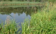
Small
wetland in Marshall County, Indiana.
Adjustments
to natural stress
In intertidal wetlands the
majority of natural stress comes from salinity and tidal movements. The
intertidal wetlands must be able to survive extreme conditions of mainly salt
water at high tide, fresh water at low tide and times of flood and brackish
water at other times. The saline water is a very difficult condition for plants
to survive in. The grey mangrove accomplishes this by excluding salt in the
root system, salt glands in the leaf, and waxy leaves to minimize water loss. However
it is vulnerable to changes in salinity levels.
Changes to tidal movements through
increased run-off or altered drainage can cause the roots of mangroves to be
inundated for longer than normal periods affecting their pneumatophones. It can
also be pushed past its threshold level if water quality is changed. Thus even
healthy ecosystems are vulnerable to change.
Some species such as
oysters and molluscs have been used as indicator species, with any decline in
their numbers indicating the ecosystem is under stress. A change in nutrient
levels may also affect primary productivity and thus bring about change.
Wetlands are often filled
in to be used by humans for everything from agriculture to parking lots, in
part because the economic value of wetlands has only been recognized recently:
the shrimp and fish that breed in salt water marshes are generally harvested in
deeper water, for example.
Humans can maximize the
area of healthy, functioning intertidal wetlands by minimising their impacts
and by developing management strategies that protect, and where possible
rehabilitate those ecosystems at risk.
Protecting
or rehabilitating wetlands
A temperate
wetland in Britain, with shallow open water and reedbeds.
Historically, humans have
made large-scale efforts to drain wetlands for development or flood them for
use as recreational lakes. Since the 1970s, more focus has been put on preserving
wetlands for their natural function—sometimes also at great expense. One
example is the project by the U.S. Army Corps of Engineers to control flooding
and enhance development by taming the Everglades, a project which has now been
reversed to restore much of the wetlands as a natural habitat and method of
flood control.
- Exclusion—Those responsible for the
management of wetland areas often facilitate public access to a small,
designated area while restricting access to other areas. Provision of
defined boardwalks and walkways is a management strategy used to restrict
access to vulnerable areas, as is the issuing of permits whilst visiting.
- Education—In the past, wetlands were
regarded as wastelands. Education campaigns have helped to change public
perceptions and foster public support for the wetlands. Due to their
location in the catchment area, education programs need to teach about
total catchment management programs. Educational programs include guided
tours for the general public, school visits, media liaison, and
information centers.
Politics
and Regulation of Wetlands Protection
In
the USA
In the United States, some
wetlands are regulated by the federal government under the Clean Water Act. Determining
the boundary between regulated wetlands and non-regulated lands therefore can
be contentious. Deciding where that boundary lies is as easy as determining the
boundary between rock-n-roll music and country music, or between legal highway
speeds and illegal highway speeds. In reality, there is no natural boundary
between the classes that humans define on these gradients (wetland/upland,
rock-n-roll/country, speeding/not speeding), and this issue is highlighted by
the US. Fish and Wildlife Service’s definition from Classification of Wetlands
and Deepwater Habitats of the United States, which defines wetlands as “lands
transitional between terrestrial and aquatic systems.” Regulations to protect
water quality and highway safety require that we create arbitrary boundaries
within those gradients, but these boundaries are scientifically definable, and
consist of areas where three criterion of the presence of hydric soils, the
presence of wetland vegetation, and the presence of appropriate hydrology. Such
regulations must be predictable, reproducible, and enforced. Otherwise, we will
sacrifice clean water for development in the case of wetlands regulation (or
vice versa), or sacrifice safe travel for quick travel (or vice versa) in the
case of speed limits. Determining which wetlands are regulated under section
404 of the clean water act or section 10 of the rivers and harbors act is
termed “jurisdictional determination.” Determining the boundary of wetland,
whether jurisdictional under sections 404 or 10, or not jurisdictional but
still meeting the technical definition of a wetland, that is having the soils,
vegetation and hydrology criterion met is called a "wetland
delineation," and generally is performed by college graduates with science
or engineering degrees working for engineering firms or environmental
consulting firms who are familiar with the 1987 U.S. Army Corps of Engineers
Wetland delineation manual. Defining a boundary depends upon soil and
vegetation characteristics; it is easier to do where the slope of the land is
steeper. Deciding if a wetland is a regulated wetland depends on classifying
the water in it as “water of the United States” or not. Classifying water as
“of the U.S.” or “not of the U.S.” for purposes of enforcing the Clean Water
Act suggests a natural boundary that probably does not exist in nature, and one
that was not created regarding air for purposes of enforcing the Clean Air Act.
Wetlands are the focus of
the US National Wetlands Coalition, which in turn has become the focus of some
controversy over "false fronts," a form of political camouflage.
Notes
- ^ Definition from Corps of Engineers
Wetlands Delineation Manual by Environmental Laboratory U.S. Army Corps of
Engineers Waterways Experiment Station 3909 Halls Ferry Road Vicksburg, MS
39180-6199
Ullah, S; Faulkner, SP.
2006. Denitrification potential of different land-use types in an agricultural
watershed, lower Mississippi valley. ECOLOGICAL ENGINEERING 28 (2):
131-140.
Wikipedia
http://en.wikipedia.org/w/index.php?title=Wetland&action=history